Charles N.Anderson,,The Surrey Iron Road and The Croydon,, Merstham and Godstone Iron Railway, article in The Southern Railway Magazine, Vol. 1, No.3, July,1923.
Philip Lane, Croydon, Merstham and Godstone Discoveries, in Railway World, August,1972.
Legend [78.8kb]
11
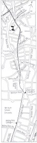
CHAPTER 13 THE ROUTE OF THE CROYDON, MERSTHAM AND GODSTONE IRON
RAILWAY
As with the Surrey Iron Railway, the chief sources for the determination of the route of the
Croydon, Merstham and Godstone Iron Railway were the tithe maps of the parishes through which it
passed, supported by property conveyance and estate maps and, in this case, by London and
Brighton Railway plans. Particularly useful were the 1st. edition 6-in. and 25-in. Ordnance Survey
maps of the area, which show then-surviving cuttings, earthworks, and related property boundaries
and footpaths.
The Croydon, Merstham and Godstone Iron Railway commenced at an end-on junction with the
Surrey Iron Railway at its terminus at Pitlake, and ran southeastwards to join and follow the line of
the present Church Road. There was no depot, but there was a toll house, apparently situated on the
west side of the railway about 60 yards north of its crossing of Church Street. Opposite this was the
Y-junction of the Croydon Canal Company's Pitlake railway, running along the course of the present
Tamworth Road.
The line of the railway continued along the whole length of the present Church Road. Most of the
northern part of this stretch was along the edge of the former grounds of Croydon Palace, a country
residence of the Archbishops of Canterbury until l780. In 1781 the Palace estate was sold to
Abraham Pitches, and by 1788 part of it was being used as a calico-printing and bleaching works,
probably by Edward Gardner and Thomas Gill, who were working there when declared bankrupt in
November, 1791. Their lease was offered for sale by auction in March,1792, and again in
October,1793. In 1798 the Palace and grounds were bought by Samuel Starey, a linen draper, at
which date the calico-printing and bleaching business there was being carried on by Joseph Ancell
and William Lane.
In 1799, Starey rented some land to the west of the Palace, opposite the parish church, from John
Hilbert. He built a mill there, on a site about half-way along the present Rectory Grove, diverted
some side streams of the Wandle to form a mill pond, and started calico-printing and bleaching there
on his own account.
In 1800, Starey mortgaged the Palace estate to John Freeborn, and the Croydon, Merstham and
Godstone Iron Railway Company purchased the land they required from Freeborn for £798-14s.
The conveyance was dated 5 January,1807, but the company had obviously occupied the land
before that date. It included a separate calico-printing mill at the north end of the Palace grounds,
worked by Francis Hudson from about 1790. This was duly demolished to make way for the
railway, and Hudson moved to Old Ford, Middlesex.
Joseph Ancell died in 1802, and it was probably soon afterwards that Samuel Starey took over the
printing and bleaching works at the Palace, whilst still working at the mill to the west of the church.
William Lane moved to Stubbs Mead, as recorded in the previous chapter.
Samuel Starey died in 1809, and the business was then carried on by his widow Elizabeth and sons
Samuel and Thomas. They later got into financial difficulties, and in 1829 the Palace estate was
offered for sale by auction. Apparently no acceptable bids were received, for the Stareys were still in
possession when they were declared bankrupt in December,1831. The property was then again
offered for sale, and part of it was bought by Benjamin Helps Starey. a cousin of Samuel and
Thomas. They were allowed to carry
Fig.18 Route Plan (1) [78.8kb]
[]
on the business, but Thomas quitted in 1823. By 1838, Samuel Starey had been joined by John
Oswald, who died in 1848 and was succeeded by his son Edward.
In 1850 the Croydon Local Board of Health, in pursuance of a policy of filling in some of the
polluted streams and ponds in the vicinity of the Palace, bought the mill to the west of the church,
which had come into the possession of William Harris in 1838, although still worked by Starey and
Oswald. They demolished it in 1852, and in return provided Starey and Oswald with a new
steam-powered mill at the Palace. Samuel Starey died in 1856, and Edward Oswald carried on alone
until 1886, when the Palace and grounds were sold and put to other uses.
Plate 7 is from a pencil drawing by "E.D. ", undated, entitled "Croydon Church (from the Iron
Railway)". The viewpoint must be from the bend in the present Church Road, at the north end of
Rylands House,
Plate 7 Croydon, Merstham and Godstone Iron Railway at Old Palace grounds [207.2kb]
although the arrangement of the buildings shown does not accord with that shown on maps of the
period. Near the site of Rylands House was a gas works, established in 1827 and operated from
1829 to 1847 by Henry Overton, who also owned a brewery and a flour mill situated nearby. Their
proximity to the railway suggests that coal and other supplies might have been delivered on it.
In its course through the Palace grounds the railway crossed a small stream, the Scarborough Brook,
probably by a plank bridge, at a point between the present Cranmer and Fawcett Roads.
The junction of Church Road with Scarbrook Road marks the limit of the former Palace grounds.
Scarbrook Road was in existence when the railway was constructed, and from what is now the
junction turned south to run into Lower Coombe Street. The railway ran along the west side of this
southern leg. When Church Road was formed on the route of the railway through the Palace
grounds, some years after its abandonment, the name was also given to the southern part of
Scarbrook Road. According to Ward, it was originally called Tramway Road [1], and Bing wrote
that it was once "locally known as Iron Road, or Tramway Road."[2]
Part of Church Road was effaced in the early 1960s when the Croydon Flyover was built, crossing
above it, but it continues on the south side of it, still on the route of the railway, to a junction with
Lower Coombe Street. Crossing the latter road, the railway ran in a slightly curved course across
land owned by Thomas Keen, and thus known as Keen's Meadow. His name is commemorated in
the present Keen's Road. Nearing Southbridge Road the railway turned to cross it a little south of its
junction with the present Parker Street. Bing reported of being told of elderly local residents who
remembered the low embankment that carried the railway across Keen's Meadow before the area
was built upon. [2]
Where the railway crossed Southbridge Road, it also crossed the River Wandle, flowing along the
east side of that road, from its sources at South Croydon. According to Corbet Anderson, at this
point "the Merstham tram went across an open arch over the stream, until a child happening to get
drowned there, they covered the arch with a grating."[3] Having crossed Southbridge Road the
railway continued its course southwards, crossing the northern arm of the present Dering Road close
to its junction with the former road, and then crossing the southern arm of Dering Road. The route
then commenced to curve towards the southeast. The first part of this curve is defined by the rear
garden walls of houses in Barham Road, adjacent to Whitstable Place. A reverse curve starting just
before the crossing of the present Warham Road brought the railway to the west side of Brighton
Road, opposite the Swan and Sugar Loaf public house. Here there was another crossing of the
Wandle (generally known, south of Croydon, as the Croydon Bourne) which ran near the west side
of the Brighton Road. The railway turned to run southwards between the Bourne and Brighton
Road.
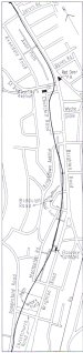
A few yards south of the Swan and Sugar Loaf was the South Croydon tollgate of the Surrey and
Sussex Turnpike Trust. Plate 8 is from a drawing of 1825 by E.Yates, looking north to the toll
house and showing a closed gate across the Croydon, Merstham and Godstone Iron Railway
trackbed (with rails and sleepers omitted), which was presumably under the control of the road
toll-keeper.
The Deposited Plan of 1802 shows the railway crossing Brighton Road just south of the turnpike
gate, to run on its east side for about 600 yards before re-crossing to the west side. As built,
however, it kept
Plate 7 Croydon, Merstham and Godstone Iron Railway at South Croydon [207.2kb]
to the west side of the road, passing along the edge of the grounds of Haling House, which was
owned at the time the railway was built by William Parker Hamond, one of the shareholders. This
house was demolished in 1927 and the Whitgift School was built on the site a few years later. Along
this stretch the railway passed in front of Haling Park Cottage. There was a building here when the
railway was built, referred to in 1812 as "the two ancient cottages or almshouses.
To the south of the school grounds an embankment is shown on the 1867 Ordnance Survey maps,
extending to a point opposite the Red Deer public house. Bing recorded in 1927 that an elderly lady
had described to him how, as a young girl, she had played games of hide-and-seek behind this embankment [2], and it was reported in 1883 that "some remains of the embankment are still visible near the Red Deer Inn." [1]
At about the crossing of the present St.Augustine's Avenue the railway curved away from Brighton
Road, then made a reverse curve to run alongside the east side of the north-to-south length of the
present Churchill Road. This was the beginning of its gradual climb up the hillside to the west of
Brighton Road. The route crossed the present Kingsdown Avenue about 60 yards from its junction
with Brighton Road, and continued on a sllgntly curved course to cross the
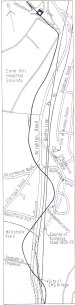
Fig.19 Route Plan (2) South Croydon to Pur1ey [78.8kb]
northern arm of Biddulph Road, about 40 yarde from Brighton Road. Thie stretch was for the most
part slightly to the east of the present footpath at the rear of the houses in Brighton Road. A footpath
on the railway route here is shown on the 1867 Ordnance Survey maps with terracing below it, and
in 1900 Paley wrote that here "the course of the line begins to be clearly marked by a line of rough
posts and wire fencing. This continues a considerable distance during which it may be plainly seen
from the Brighton Railway, passing a large quarry on the way."[4] It was about here that Charles
Anderson noticed in 1923 that "the 'shelf' on the hillside indicating the course of the tramway can be plainly seen."[5]
Biddulph Road was built in the old limestone quarry mentioned by Paley, first recorded in 1809 as
the Haling Lime Works. These may have been established to take advantage of the facilities offered
by the railway. The route of it crossed between northern and southern arms of Biddulph Road and
continued on its southward course across the hillside. Here, again, there is a public footpath near to,
but not exactly on, the railway route, and it was along this stretch that Charles Anderson found that
"the parallel ridges of the line of stone sleepers can still (i.e. in 1923) actually be seen."[5] Ellis, however, visiting the site in 1934, reported that although the "shelf" was once visible, "in the past five years or so has disappeared in the gardens of new houses."
[6]
The footpath comes to an end about 300 yards south of Biddulph Road, but turns at right-angles and runs down to Brighton Road, alongside the north end of a terrace of houses called Florence Cottages (Nos.680-694). Beside the south side of these cottages another path runs up the hill from Brighton Road, and from this path can be obtained a view of the retaining wall at the rear of the gardens of Florence Cottages. The cottages were built about 1850, but the plot was enclosed prior to this and the wall was probably built then to permit the levelling of the garden ground and to form a boundary just below the previous shelving. On the line of the railway at the top of this wall, Lee in 1931 claimed to have detected what "would seem to have been a depot of some size....... two
sidings seem to have existed alongside the main line."[7]
This conclusion is questionable; such a
feature is not shown on any maps, and there would have been no need for it at this point.
From Florence Cottages the route of the railway, again indicated by terrace banking on the 1867
Ordnance Survey maps, sweeps away from Brighton Road, crossing over the present footpath behind
the houses in that road, and crosses the present Montpelier Road at the rightangle corner. Along this
stretch, Ring reported that "the double width and sleeper hollows were still fairly conspicious."
[2]
The route continued across the north corner of the Christ Church Primary School grounds, across the
bottom of the gardens to houses in Pampisford Road, and into the Purley Rotary Field recreation
ground. The site of the school was, in the 1980s, occupied by the Purley Lawn Tennis Club, and in
September,1937, a rail was unearthed there during alterations to the Club grounds. [8]
The railway route across Purley Rotary Field is followed by the tarmaced path running north to
south and the level stretoh alongside it. At the north end of the path are displayed two Croydon,
Merstham and Godstone Iron Railway rails, set on four stone sleeper blocks (on rather too wide a
gauge), within a railed enclosure, with an explanatory notice. These were set up when the Rotary
Field was opened to the public in 1925, and came from the Merstham quarries area.
Bing had surveyed the route across the Rotary Field when it was still "undisturbed meadow land",
and referred to the track as "distinctly marked by the terracing and banking that had been
necessary", and remarked that one "could still trace most of the hollows in which had been laid the
stone sleepers that carried the rails", and that "no levelling of the track had taken plaoe."[2] Rev.
Robert Resker noted in 1916 the site of the railway there, "still clearly seen" and "marked by a row
of ancient may bushes."[9] Adjoining Rotary Field on the south side was the vicarage of Christ
Church, Purley, in which Resker lived, on the site of the present Christian Science church. The
railway ran just to the east of the vicarage site, and Resker recorded that in the garden, some 25
years earlier, during the making of flower beds, "the bed of flints had to be dug through and the
stones (i. e. the sleepers) removed."[9]
The route crossed the present Christchurch Road, and continued on to run along the east side of the
present Pampisford Road to its junction with Russell Hill Road. The latter road was on the boundary
between the parishes of Croydon and Beddington, and at its junction with Brighton Road was the
Foxley Hatch toll gate of the Croydon and Reigate Turnpike Trust.
After crossing Russell Hill Road, the railway ran beside the east side of Foxley Lane, then turned
across the site of the west wing of Purley Public Library. A plaque on the wall of the library,
installed in July,1993, records the fact that the railway ran across the site. This part of the line, from
Russell Hill Road to just beyond Banstead Road, was on an embankment, marked on the 1867
Ordnance Survey maps. Paley wrote in 1900 that "the raised horse tracks and a few sleeper holes full of grass may yet be seen along here. Just beyond comes a genuine little bit of embankment, much grown over with grass and bushes."[4]
Part of the embankment had been cut away when Anstead Road was built in the 1890s. In 1934 Ellis remarked that "the bank is still visible from Anstead Road. Its level is several feet above Banstead Road."[6]
A year later this piece disappeared when the library was built on the site.
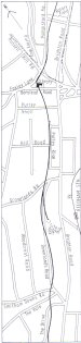
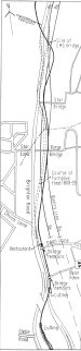
The railway continued in a southwesterly direction from Banstead Road, on a gently winding
course, running close to the west side of Purley Rise, crossing Grovelands Road about 50 yards west of its junction with Downlands Road. After running parallel to the west side of Downlands Road, approximately on the site of the houses, it turned to cross the road at about the point where an alley runs down to Brighton Road. Then it turned again to run on the site of the houses on
Fig.20 Route Plan (3) Purley to Coulsdon [78.8kb]
the east side of Downlands Road, and crossed that road at its junction with Smitham Downs Road.
Part of this stretch was identified by terracing on the 1867 Ordnance Survey maps. At the rear of the
Council Offices on the east side of Brighton Road was the site of a small gravel pit, and a branch
from the railway ran down to it from a junction just south of Grovelands Road. Bayliss noticed the
pit, but misplaced the branch showing it further south.
Fig.21 Route Plan (4) Coulsdon [78.8kb]
From Smitham Downs Road, the railway continued on across the present The Vale and the north
corner of The Drive, where a short length of terracing was shown on the early Ordnance Survey
maps. The route was then approximately on the line of the houses on the east side of The Drive,
where further terracing was shown on the 1867 maps. Thence it continued its southwesterly course,
crossing the present South Drive, and the junction of The Grove and The Avenue, and across the
route of the Tattenham Corner Railway. It ran close to the east side of the latter railway to a point
just short of the footbridge carrying a path from Woodman Road, where it curved sharply in a
quadrant to run southeastwards, and crossed from Beddington parish into a corner of
Woodmansterne parish. The line then crossed the present Woodman Road, then Chipstead Valley
Road at the spot where the Elim church, built in 1926, stands on the northwest side. The railway
here was on a high embankment, shown on the 1867 Ordnance Survey maps on both sides of
Chipstead Valley Road, and was carried over that road by the first substantial over-bridge on the line. At this point was the boundary between Woodmansterne and Coulsdon parishes. The bridge was depicted in a watercolour painting by G.B.Wollaston, dated 1823 (Plate 9).
A description of the then-extant embankment on the northwest side of the road was given by Paley
in 1900: "...a large piece of embankment, curving a little to the left. On top of this the holes where
the stone blocks rested are very plainly to be seen, especially in what we should call the up-line ...
the embankment is about 20 feet high where it ends on the north side of the road ..... but it is only 18
feet wide at the top."
He also noted,
"An isolated bit of embankment on the south side of the road, but lately very perfect, made of chalk,
but has mostly been carted away. After a short break beyond, another piece is visible in the farmyard
of Cane Hill Asylum."
[3]
[4]
A portion of the latter length still remains in the grounds of Cane Hill Hospital, and can best be seen
from the carpark in Lion Green Road.
Croydon, Merstham and Godstone Iron Railway bridge over Chipstead Valley Road [207.2kb]
Bing reported in 1927 that on top of it "there still-lies one of the old stone sleepers."[2]
On Brighton Road, at about the junction with Lion Green Road, was the Hooley Lane toll gate of
the Croydon and Reigate Turnpike Trust. About 350 yards north, on the east side of Brighton Road,
is the Red Lion public house, on the site of many earlier inns of the same name, first shown on a
map of 1680. It is one of the few buildings named on the Deposited Plan of the railway.
From the remaining embankment, the railway carried straight on across the present farm buildings
until about the site of the main drive to the hospital, then turned sharply to run across the fields, and
approximately parallel to Brighton Road. According to Bing, many of the sleeper blocks "were at one time lying about the grounds, but eventually were gathered together and a rock garden constructed. Most of them were broken up in the process, but a few remain entire." There is no sign of these today.
Continuing across fielde, the railway reached the present Hollymeoak Road about 50 yards west of
its junction with Brighton Road. It is claimed that the route is marked by traces of terracing in the
fields, but such irregularities are at various levels and it is not easy to precisely relate any to the
route.
From Hollymeoak Road the railway continued on across Brighton Road, then the two sets of railway tracks (the original London and Brighton route and first, the later "Quarry Line"), and
Fig.22 Route Plan (5) Coulsdon to Chipstead [78.8kb]
then curved round to re-cross the railway lines and Brighton Road, the latter at about 30 yards past
its junction with Woodfield Hill. The route of the original turnpike road left that of the existing road
about 200 yards north of its junction with Hollymeoak Road, and curved eastwards in a wider
sweep than the Croydon, Merstham and Godstone Iron Railway, and at a higher level, rejoining the
existing road route about 230 yards south of its junction with Woodfield Hill. The nearly straight
length of Brighton Road connecting the two points of divergence was part of the diversion of the
road carried out in 1839 by the London and Brighton Railway Company, as described in Chapter 8.
Thus the Croydon, Merstham and Godstone Iron Railway did not cross the turnpike road in this
length. (Reference to Fig.22, Route Plan (5) should clarify this arrangement. )
The route of the former turnpike road to the east of the present railways is defined by part of the
present Woodplace Lane and the former drive to Hooley House (later, from 1912, the Ashdovn Park
Hotel, and demolished in 1971), now followed in part by the present Ashbourne Close. According to
Bing, a number of sleeper blocks placed along the drive to the hotel had recently (i.e. 1927) been
collected up and formed into a rockery [2].
After the last-mentioned crossing of the present Brighton Road, south of its junction with
Woodfield Hill, the Croydon, Merstham and Godstone Iron Railway ran through the site of gardens
and then across a field, passing from Coulsdon parish into Chipstead parish, curving back towards
Brighton Road to cross it on the level at a point about 35 yards south of a footpath, signposted "to
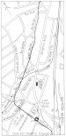
Starrock Wood and Chipstead." Continuing on, the route again crossed the two modern railways, and on the western one (the Quarry Line ), just before the bridge that carries it over the older London and Brighton line, is the site of a bridge that carried the Croydon, Merstham and Godstone Iron Railway over the older, pre-turnpike road to Reigate. This road was superseded when the turnpike road was constructed in 1808, but the old road remained in use for local access and the bridge was retained, until swept away when the London and Brighton Railway was built. Farey wrote, of this bridge, "the road is sunk considerably in order that the rail-way with its proper descent may pass over it."[10]
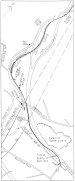
From the bridge site the railway, crossing from Chipstead parish back into Coulsdon parish,
curved slightly to the east of the modern railway lines, then turned southwards to cross the "Quarry Line" and run pretty well on the course of the older Brighton line until about the present Star Bridge. The turnpike road, from opposite Star Bridge southwards to the junction with Church Lane,was again diverted by the Brighton Company in 1839, onto the present course of Brighton Road. The turnpike road ran on a slightly curved line to the east, between the sites of the two present railways. The Croydon, Merstham and Godstone Iron Railway ran close to the east side of the turnpike road, and thus both were effaced when the London and Brighton Railway was built. This deviation was not picked up by Bayliss or Townsend, who both showed the Croydon, Merstham and Godstone Iron Railway course close to the present Brighton Road. About halfway between the present Star Bridge and Forge Bridge, the railway crossed from Coulsdon parish into Merstham parish.
From about the junction with Church Lane, where the Brighton Road resumes the turnpike road
course, the Croydon, Merstham and Godstone Iron Railway had commenced to run in a cutting, and Dean Lane, about 200 yards to the south, was carried over this by a brick bridge (Plate10). It is still there, much rebuilt and repaired, and with the arch blocked up, by the side of the Happy Eater restaurant. The south parapet has gone, and the cutting on that side has been
Fig.23 Route Plan (6) Chipstead to Merstham [78.8kb]
[
Plate 10 Croydon, Merstham and Godstone Iron Railway bridge at Dean Lane, c.1910 [207.2kb]
[Plate ll. Croydon, Merstham and Godstone Iron Railway
Plate ll. Croydon, Merstham and Godstone Iron Railway bridge at Merstham, c.1900 [207.2kb]
infilled. Beyond this, at intervals, slight traces of the cutting can be discerned in the gardens of the
houses fronting Brighton Road.
About 200 yards further on, another bridge, similar in design to previous one, carried a lane leading
to Dean Farm. The whole area has been levelled, but the bridge parapet still remains on the north
side, forming a garden boundary wall about two feet high. South of this, further traces of the cutting
appear in the gardens of the last two houses along this stretch of road. From this point, until the M23
motorway was constructed in 1972, the cutting was continuous, running alongside Brighton Road as
far south as a point opposite the junction with Harps Oak Road. The original alignment of Brighton
Road was then altered, and some portions of the cutting infilled and built over. In the course of this
work, a few sleeper blocks were unearthed
[11]. It was in the vicinity of the former commencement of the cutting that the route of the railway as shown on the Deposited Plan crossed from the west to the east side of Brighton Road.
The first stretch of the remaining cutting, running a little to the east side of the northbound lane
from the M23, commences just south of the overbridge for the intended, but never built, main M23
route, and runs southwards for about 470 yards where it is infilled at the crossing of the M23
northbound lane over the southbound A23 lane. This length of the cutting is not readily accessible.
Almost opposite the end of this cutting, on the west side of the old Brighton Road (now the northbound lane of the A23), and about 330 yards south of the junction with Glebe Road, stands Fox Shaw. Now a private house, this was formerly the Fox Inn, from near which the trial run in
1805 commenced, as described in Chapter 5. A plaque on the wall commemorates its railway
connection, and built into the front garden wall are four of the sleeper blocks, which came from the Merstharn quarries area. The level of the railway, in its cutting opposite here, was about the summit level, the line having climbed at a steady 1 in 120 gradient from Croydon. From here the railway descended at approximately the same rate to the Merstham quarries.
Beyond the bridge carrying the northbound lane of the M23 over the southbound lane of the A23, the cutting re-appears adjacent to the east side of the latter road, and continues for a further 370 yards or so, with an infilled section about halfway along. This is the deepest part of the cutting. The northern section was modified when the motorway was built, but the southern part is still an impressive feature, and is easily accessible from the road.
About 90 yards beyond the end of the remaining cutting, just north of the front garden of No.185
London Road North, two brick walls rising a foot or so above ground level mark the site of a third
bridge over the railway, which carried a track which ran to Netherne Lane to the northeast. (Plate ).
This was built mainly of stone, but with brick arch and parapet walls. The original parapets were damaged in 1971 during the installation of a gas pipe line nearby, and were later rebuilt.
At this point the route of the railway and the road had begun to curve towards the east, and about
170 yards past the bridge site is Weighbridge Cottage (No.201), now a private house but formerly the toll house
Fig.24 Route Plan (7) Merstham [78.8kb]
of the Croydon, Merstham and Godstone Iron Railway. The tracks ran immediately in front of this and continued on an easterly course, while the road bends towards the south. Originally the turnpike road made a wider sweep towards the east, and the present comparatively straight length into Merstham village was another diversion carried out by the London and Brighton Railway Company in 1839.
The railway crossed the present Shepherds Hill near the east end of the bridge over the M23
motorway, but at a lower level, and ran along the course of the track alongside the motorway to a
point about 300 yards past the junction with Jolliffe Road. The former continuation of the track
thence, still on the line of the railway, was obliterated by the motorway. At about 100 yards before
the replacement track turns to enter a tunnel under the motorway, was the termination of the
Railway. Just before the terminal point, a short branch curved westwards to an entrance to a stone
mine.
Had the intended extensions to Godstone and Reigate been built, the line would have turned at this
point to run southeastwards across the present Rockshaw Road and at about 170 yards beyond it
would have bifurcated, the line to Godstone running eastwards, and that to Reigate westwards.
The early history of the limeworks and stone mines, as operated by Jolliffe and Banks, and later by
George Valentine Hall and his family successors, was outlined in Chapter 8. Subsequently, Hall and
Company relinquished the lease in 1864, having established limeworks at Coulsdon and elsewhere,
and built their head office at Croydon. The working of the stone mines had ceased by about 1900.
By 1870 the limeworks had been taken over by J.S.Peters and were worked by him and successive members of his family until 1934 when the Merstham Grey-Stone Lime Company was formed. This company ceased working in 1956, and in 1961 the Croydon Corporation bought the site and used the quarry area for the dumping of domestic refuse. The virtual obliteration of the site was completed by the building of the M23 motorway in 1972.
Back on Brighton Road, just past the junction with Shepherds Hill, is Exchange House, now in use as an Indian restaurant, but formerly the Jolliffe Arms public house. Just to the south of this, by the side of a track leading down to a former smithy, was the display of 14 plate rails, as mentioned in Chapter 11. Although the rails have disappeared, the stone sleepers remain, embedded in concrete, but now much overgrown, together with a delapidated notice board. Finally, in Merstham, opposite the Feathers Inn, is a small garden, in which are displayed four rails set on six sleeper blocks. The rails came from the Godstone Hill quarries, but the sleepers are from the Croydon, Merstham and Godstone Iron Railway.