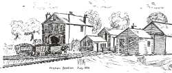
Officially, traffic on the Surrey Iron Railway ceased on 31st August 1846. However, on the Wimbledon Parish Tithe Map of 1850, the parcel of land which now forms the crescent section of Bygrove Road has indications of a type that on a more modern map, would be taken as shewing a tramway or light railway. The area is identified as Parcel 284 and in the 1851 apportionment this is described as owned and occupied by John Childs. It consists of House, Garden, Plantation, Millhead water, Mill, Stableyard, TRAMROAD (author's emphasis) and Paddock. The equivalent for Mitcham Parish shews a continuation of this area as Parcel 194, owned by Henry Houd, occupied by John Allnutt and described as Cottage, Garden and ROAD. This latter map makes obvious that the piece curves out from what must have been the equivalent of the local station. The straight part of Bygrove Road also runs to the same area and may, therefore, be of a similar foundation.
| [Full size image 42.6kb] |
Have we therefore, indications that what E W Brayley. & E Walford in "A Topographical History of Surrey" (1850) described as "Small detatched portions" still working, could actually have been quite extensive at the northern end ?
We know for certain that when the London & Southampton (1835) and Richmond (1846) Railways were built, they had to bridge the Surrey Iron Railway without impeding the older line.
The Railway Dock at Wandsworth was still being used in 1865 by MacMurray, the proprietor of the Royal Paper Mills in Garrett Lane. He used it for the import of, amongst other things, esparto grass, which was one of his more important ingredients in the making of paper.
Garratt Copper Mill, Plough Lane
One of the finest and most powerful water whee1s in the country. Over 150 years of age, it is still going strong, supplying the power for the Chamois and "white leather" works to which it is attached."
(Martin Shaw, 1938)
|
Furthermore, at this time the dock was extended to serve the brewery of Messrs. Young & Bainbridge (now Young & Company). Road maintenance was at this period basically restricted to the turnpikes. The local ones of which did not follow the valley of the Wandle, and the toll charges would have created unwelcome additional expense which manufacturers would have been only too pleased to avoid. Hence it would have made economic sense for the various entrepreneurs between the dock and Merton High Street to have clubbed together to continue to run this remainder as an industrial tramway. Maintenance costs would have been minimal with plenty of secondhand rails available from the rest of the line (this, by the way, was by this time the normal method of repair in any case).
Furthermore the wager placed by a Mr Banks on the opening day of the closely related Croydon Merstham and Godstone Iron Railway was already part of the local folklore. He had set an apparently impossibly high figure on the haulage ability of one horse. What resulted far exceeded his wildest dreams, since eventually the maximum load was somewhere between 50 & 55 tons hauled at 4 miles per hour.
We can be fairly certain that until at least the 1860's there was still a level crossing over Wandsworth High Street, if only to serve the needs of MacMurray. Between there and Terriers Bridge (now Colliers Wood Bridge), the only road crossings were at Brentwood & Plough Lanes, and this latter basically ran to the Copper Mills in Coppermill Lane. Until 1868, any manufacturers and millers in the vicinity of Terriers Bridge had no economical transport system for their raw materials and goods, which was when the Tooting and Wimbledon Joint Railway opened.
Hence the question must remain as to why the tramway in Bygrove Road was still in use if there was no connection at the northern end.
Roger Hardman, from an article in the Wandle Industrial Museum Newsletter No 3 of 1984
|
|
|
|